farming and agriculture
The Sky Farmers: How Drones Are Revolutionizing Agriculture
Drones, or unmanned aerial vehicles (UAVs), have transcended their origins as military tools and techie playthings to become indispensable in modern agriculture. By combining multispectral imaging, data analytics, and precision farming techniques, drones are addressing some of the most pressing challenges in agriculture, from increasing crop yields to conserving resources.
Picture this; It’s early morning in the rolling farmland of Iowa, and the hum of a drone slices through the stillness. From above, the drone’s camera captures a tableau of golden fields and green pastures, but it’s not there to marvel at the scenery. This mechanical eye in the sky is meticulously analyzing the crops below, identifying nutrient deficiencies, monitoring irrigation, and scanning for pests. For farmers, it is the dawn of a new era—one where technology is as much a part of the harvest as soil and sunlight.

The Many Benefits of Agricultural Drones
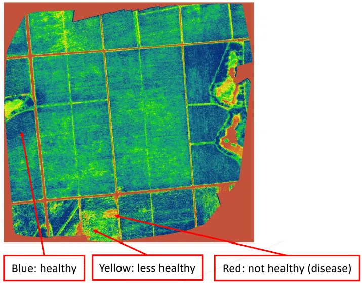
The applications of drones in agriculture are as varied as the crops they monitor. One of their most impactful roles is in crop scouting. Traditionally, farmers would walk their fields to identify issues—a labor-intensive process prone to human error. With drones, farmers can cover hundreds of acres in minutes, gathering high-resolution images that pinpoint trouble spots. These images, processed with advanced software, reveal details invisible to the naked eye, such as early signs of disease or water stress.
Another significant advantage is precision agriculture. Equipped with multispectral sensors, drones can measure the health of crops by analyzing light reflection patterns. This information allows farmers to apply fertilizers, pesticides, and water with surgical precision, reducing waste and lowering costs. For example, a drone might reveal that only certain rows of a field need additional irrigation, enabling targeted intervention that conserves water—a critical resource in an era of climate uncertainty.
Drones also play a pivotal role in soil analysis and seeding. By creating detailed topographical maps, drones help farmers understand the contours and composition of their land, guiding planting strategies. Some drones are even capable of planting seeds directly, a boon for reforestation efforts and farms in remote or difficult-to-access areas.
Finally, drones contribute to sustainability. By reducing the need for heavy machinery and excessive chemical usage, drones help lower the carbon footprint of farming operations. In turn, this aligns agricultural practices with broader environmental goals, a crucial consideration for a world grappling with climate change.
WHAT IT LOOKS LIKE
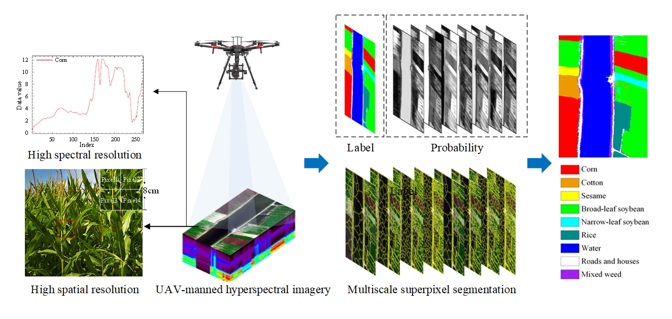
Within aerial imagery, two primary types stand out: multispectral and hyperspectral imagery. Each offers its advantages and is tailored to meet specific agricultural needs. Whether gaining a broad overview or analyzing the finer details of crop health, these technologies are reshaping the agricultural landscape, offering tools as diverse as the fields they survey.
(Below is an illustration of crop classification using aerial remote sensing. image referenced from MDPI)

The Future: From Flying Tools to Autonomous Farm Managers
As drone technology continues to evolve, its potential in agriculture is set to expand exponentially. The next generation of drones will likely feature enhanced autonomy, allowing them to operate without human oversight. Imagine fleets of drones working in tandem: one scouting for weeds, another spraying herbicide, and a third monitoring weather patterns—all coordinated by artificial intelligence.
Battery life and payload capacity, currently the Achilles’ heels of drones, are also expected to improve. Longer flight times and heavier lifting capabilities will make drones viable for tasks like transporting harvested crops or deploying large-scale irrigation systems. Integration with Internet of Things (IoT) devices on the farm could enable real-time data sharing, creating a fully connected ecosystem that optimizes every aspect of agricultural production.
Regulatory advancements will play a significant role, too. As governments refine drone-related policies, farmers will gain greater clarity and freedom in how they use this technology. The development of dedicated agricultural airspace corridors could further streamline operations, ensuring drones can operate safely and efficiently.

The Sky’s the Limit
The global agricultural drone market, valued at $1.2 billion in 2022, is projected to grow to $6.5 billion by 2030. This growth underscores the profound impact drones are having on farming practices worldwide. Yet, their significance extends beyond economics. By democratizing access to advanced farming tools, drones are leveling the playing field for smallholder farmers, empowering them to compete with industrial-scale agribusinesses.
As drones become as common as tractors in the agricultural landscape, they herald a future where farming is not just about cultivating the earth but mastering the skies. It is a future where the age-old rhythms of agriculture harmonize with cutting-edge technology—a future that, quite literally, is looking up.
